Report this service

I create orthophoto maps using aerial and satellite imagery

  • Delivery Time
    5 Days
  • Languages
    Urdu, English
  • Location

Service Description

Hello!

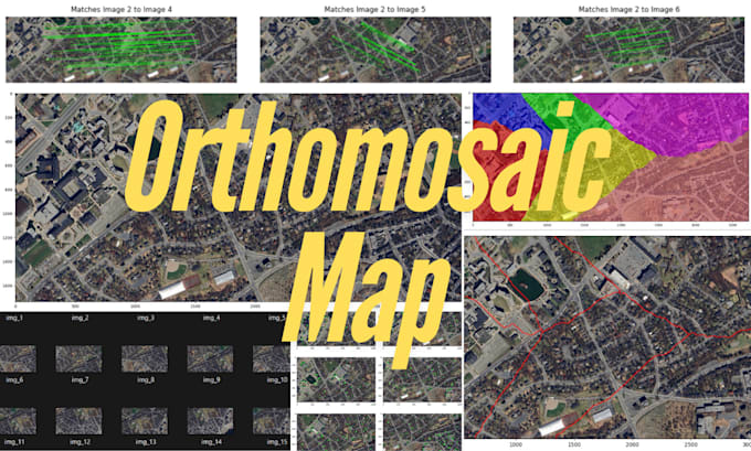
I am an experienced Aerospace and Electrical Engineer specializing in high-quality orthomosaic maps created from satellite and drone imagery. I offer precise and reliable mapping solutions tailored to your requirements, whether for detailed land surveys, construction monitoring, agricultural assessments, or environmental studies.

Why Select My Service?

Advanced Image Processing

  • ORB Feature Detection: Ensures accurate keypoint alignment
  • Homography Estimation: Provides seamless stitching with minimal distortion

Seamless Image Stitching

  • Registration & Compositing: Facilitates efficient image alignment
  • Wave Correction: Delivers distortion-free maps

Optimal Blending & Compensation

  • Seam-Based Merging: Creates smooth transitions
  • Multi-Band Blending: Ensures consistent exposure

Precise Cropping & Masking

  • Largest Interior Rectangle: Focuses on areas without borders
  • Panorama Mask Creation: Improves accuracy

Services Provided:

  • High-Resolution Orthomosaic Maps
  • Data Analysis & Reporting
  • Custom Solutions
  • Fast Turnaround & Reliable Service
  • Unlimited Revisions

Ideal For:

  • Construction & Infrastructure
  • Agriculture
  • Environmental Monitoring
  • Real Estate & Urban Planning

Let's collaborate to create detailed maps!

Reach out to begin your project today.

200.00
I will generate an orthomosaic map using satellite and drone imagery
5 Days Delivery
1 Revisions

About The Seller

AsyncGenius
0.0 (0 Reviews)
Rate: 46.00 - 53.00 / hr